
We looked at several potential locations to build the scheme within about 2km of the Woodend Low Level. The key factors we consider when looking for land for a mine water treatment scheme include:
- A large enough area to build the scheme
- Distance from the Woodend Low Level (mine entrance)
- Distance from residential properties and businesses
- Is it downhill of the Woodend Low Level (mine entrance)?
- How will we return the treated water to Gategill Beck?
- Access to the site for construction vehicles and during operations.
- Is the land suitable for construction: steepness of slopes, flood risk, ground conditions etc.
- Is the site protected as a site of special scientific interest or scheduled monument (archaeology)?
- Are the landowners interested in leasing or selling their land?
We investigated potential sites in several phases, summarised on the map below:
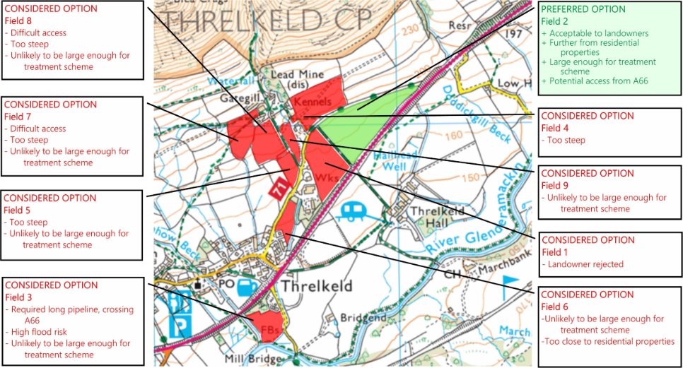
2012: Atkins:
- Three sites considered (Field 1, 5 and 6)): all rejected after further engineering investigations and discussions with landowners.
2017: Mining Remediation Authority map-based review
- Considered land within a 2.5km distance from the Woodend Low Level with criteria including:
- Slope steepness and elevation
- Risk of surface water flooding
- Conservation designations (ecology, archaeology)
- Further potential sites identified for further technical investigations and discussion with landowners.
2017+: CDM Smith Technical Review
- Land adjacent to sewage works (Field 3 on map) rejected due to distance and complexity of installing pipeline from the Woodend Low Level.
2018 to 2024:
- Discussions with landowners at the preferred location (Field 2 on map).
- Initial surveys of ecology and ground conditions suitable.
- Option to lease the land signed with landowners (2024).
- Further surveys of ground conditions to be carried out (2024 onwards).